Right: On St. Julian's Road at the junction with Barns Hill road that comes from Peasdown St. John. Right: The drop down Single Hill road to the Halt site.
SOMERSET & DORSET RAILWAY WALK
SHOSCOMBE VALE & SINGLE HILL
(13th of Aug. 2019)
Following
along St. Julian's Road from Shoscombe you come to a road
junction/crossing. Straight ahead would take you on to Wellow but you
turn right
here and ad down Single Hill for the station site.
It
is a disappointing that there is so little to see of Single Hill Halt.
It has been completely cleared and that actual halt site is wildly
over grown. It was with
thanks to a local couple that they showed me the actual site and
allowed me to walk around and try to get some useful photographs. It
would be nice if it
was possible for the Somerset & Dorset Track bed group to put
this site back together as they have and are doing to other S&D
station sites. It was a
straight forward double track, two platform halt of concrete built
platforms.
Right: On St. Julian's Road at the junction with Barns Hill road
that comes from Peasdown St. John. Right: The drop down Single
Hill road to the Halt site.
The village road junction. Turn right for the Halt site. Continue down
the hill to the Ex railway bridge site.
Both. Single Hill Road runs east to west from one end of the village
to the other. Both are dead ends as far as traffic is concerned.
Right: The Halt site is within the trees on the left at the far end of
this road.
By the village road there is a sign dedicated to the Halt.
From the village road the first view of the station site which in
along the treeline to the left.
Looking towards Bath along the two platforms. Left: Just
overgrown grass, some washing and the way blocked by a fence and
trees.
From the fenced off spot ahead of the washing
Telephoto from the same spot as above right.
Looking west towards Radstock. The way up to Shoscombe Vale is blocked
off and the track bed unwalkable.
However, there is a footpath that takes you back into Shoscombe but is
very narrow and over brown. The
track bed can't be seen.
Just down the bank at the west end of the station I was assured there
are some sleepers but they were too ingrained in the undergrowth that
the couldn't
be seen. Right: A piece of concrete does show up.
From the village road. Shoscombe Vale end of the children's play
ground and the fenced off way by the washing.
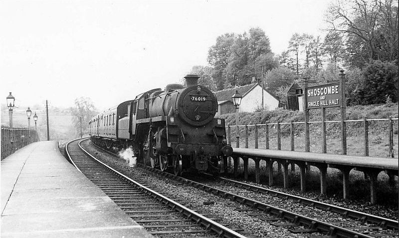
Old photos

Shoscombe & Single Hill Halt as it was in the 60's. A train has
just arrived from Radstock. (Author Unknown).

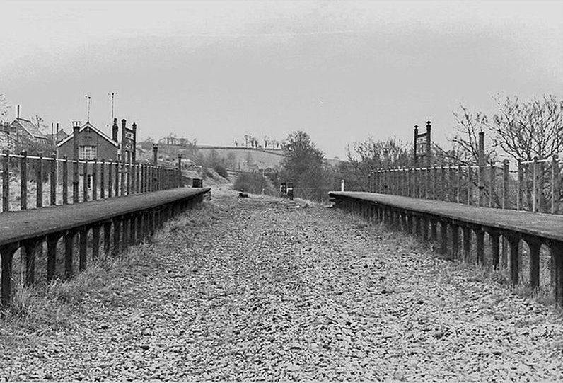
From close to the same spot as above

Looking towards Bath. After the rails have been lifted. You
can see the tops of the under bridge abutments.
(Author Unknown).

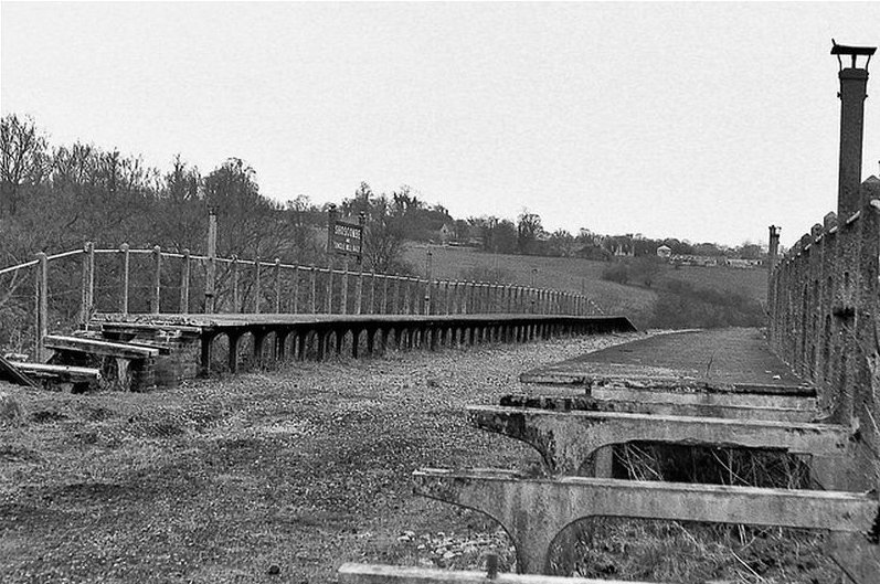
Wellow end of platforms looking towards Radstock. The platforms were
staggard. (Author Unknown).

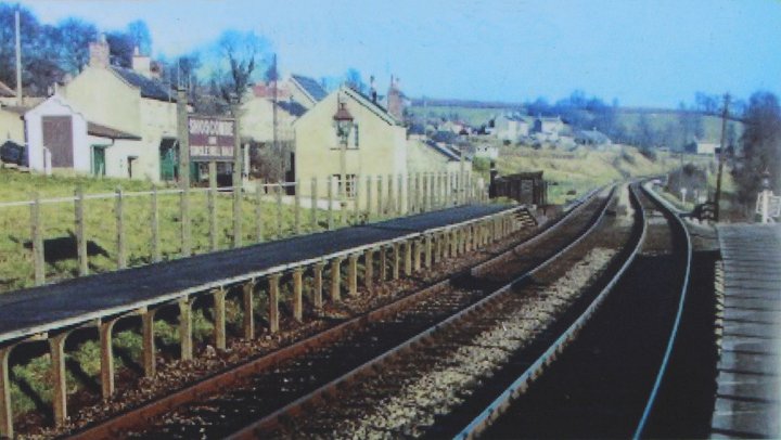
Cropped from the official notice board. Towards Wellow. The now
demolished under bridge is immediately
at the end of the platforms. This is roughly where the children's play
area is today.(Author Unknown).
At the demolished under bridge at the bottom of the hill.. The Halt
was up on the right.
Looking back up to the main road through the village.
Left: Remains of the Radstock side of the bridge
abutment.
Right: Remains of the Wellow side of the bridge abutment.
Left: The brook at the bottom of the hill. It was interesting to find
these anti-tank blocks still in place. There must have been military
connection with
this area during the war! Right: Looking up the railway embankment
from the same spot.
You
can only see the track bed by walking through the village to the north
end where you can look down on the track bed
as it leaves Single Hill and towards Bath. Again, the track bed is
unwalkable from here all the way to Wellow station site.
Left: From the village road looking down on
the track bed, as it comes in from the Halt. Right: From the same spot with the
track bed heading towards Wellow.
The track bed heading towards Wellow. From the northern end of
Shoscombe & Single Hill Halt.
Final photo. I
was tempted to try and get down onto the track bed but the only way
through private land and I could not
see anyone about whom I could have asked. However, you can only
walk a short way beyond before it becomes blocked.
There
is every possibility that the Halt and track could be rebuilt along
this length and make an interesting S&D attraction and not
impossible.
Likwise getting through to Wellow but that would take a lot more
effort and expense but it could be hard work and expensive. but
who knows,
perhaps one
day!
This concludes all the possible railway walk from Bath to Midsomer Norton.
===========================================================================
Other
railway walks:
The Dundee & Newtyle Rlwy Walks Opened in 1831 the route had three incline planes. The
first was from the terminal station on Ward Street, up the
Dundee Law, where there was
also a tunnel. The second was the Balbeuchley incline at
Rosemill and the third at Hatton that ran down to Newtyle station.
It was also the very first passenger train service in Scotland.
Worked by Horse over the levels until the first steam engine was
purchased in 1833. Came under the Caladonian Railway with it's
terminal moved to Dundee West station. Passengers
service ended in 1952 and the line totally closed in the mid 60's.
The inclines were by-passed in the 1860's.
The Cromford & High Peak Incline
railway in Derbyshire has been luckier in having much of it's
buildings, including an Engine House preserved. This is what could have
happened with
the D&N, indeed, should have happened with at least one of the
D&N inclines. However, the C&H gives an excellent comparison
of what
the D&N would have looked like, albeit the
inclines were only single track.
Boddam To Ellon Branch (Walks) By Bill Reid. Ex GNSR branch line.
Dyce To Fraserburgh and Peterhead Walks. Ex GNSR
Bath To Wellow Rlwy Walks Ex Somerset & Dorset Rlwy.
The Test Valley Railway Walk. (New Mills To Hayfield).
All My Web Sites (Web Pages, Flickr and Videos).
Hosted by www.theatreorgans.com